


boussole et sac a dos 280225

JMCMoreau
User
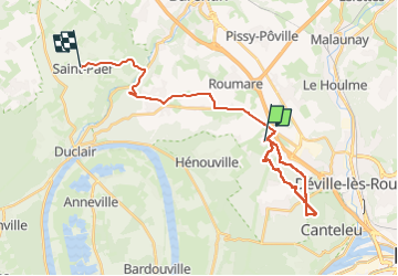

Length
25 km

Max alt
150 m

Uphill gradient
285 m
Km-Effort
29 km

Min alt
16 m

Downhill gradient
307 m
Boucle
No
Creation date :
2025-02-28 12:59:39.659
Updated on :
2025-02-28 16:29:43.441
3h29
Difficulty : Easy

FREE GPS app for hiking
 SityTrail
IGN / Geographical institutes
SityTrail Plus
The world is yours!
About
Trail Walking of 25 km to be discovered at Normandy, Seine-Maritime, La Vaupalière. This trail is proposed by JMCMoreau.
Positioning
Country:
France
Region :
Normandy
Department/Province :
Seine-Maritime
Municipality :
La Vaupalière
Location:
Unknown
Start:(Dec)
Start:(UTM)
354710 ; 5483525 (31U) N.
Comments